Week 163: Highland Park
February 17, 2019Southwest Museum / Eldred Stairs, 2.6 miles, 196+ stairs
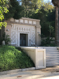
Charles Fleming's simple, but not easy, hike from the April 28, 2012 issue of the L.A. Times had a little bit of everything Barbara and I like about urban hiking: neighborhoods with a past, historic homes, long staircases, great views, and a biggest/best of something—in this case, a street. We began on the elevated sidewalk in Highland Park at Woodside Drive and walked east along Figueroa past Casa de Adobe (1916) a CA Historic Monument replicating an adobe home from CA's early 19th century rancho/pastoral era when this area was part of Rancho San Raphael. Developers purchased the land during the 1880s land boom and created the Highland Park housing tract—add two rail lines, you've got yourself one of the first subdivisions in Los Angeles that led to a creative, early 20th century bohemian community. At the end of the elevated sidewalk at Sycamore Terrace, we stopped at another Historic Landmark: Hiner House, built in 1922 with stones from the Arroyo Seco by KC band leader and music professor Edwin Hiner. Between 1898 and 1912, Occidental College was situated in Highland Park and many Oxy professors occupied Craftsman homes built along Sycamore between 1903-1912, dubbing the block "Professor's Row," a Historic Preservation Overlay Zone. But Barbara and I bypassed Prof Row to head north on Ave. 50 for a five block walk to the "star" of this hike, Eldred Street and the Eldred Street stairs. A small street in a nondescript neighborhood, Eldred Street is the steepest drivable street in the state of California! Constructed in 1912, Eldred's 33% grade is so steep that the city has special small garbage trucks for trash collection—the regular trucks would topple—and it has its own group mailbox at the base for postmen. Barbara walked up Eldred backwards, enjoying the view, while I huffed and puffed forward at a 45-degree angle (that's what it felt like.) At the top, a 196-step staircase led us up to Cross Avenue, where a lucky weather break between rainstorms gave us a blue-sky, cloudless view of the San Gabriels with distant snow-capped peaks to the north, and Ernest E. Debs Regional Park in the western San Rafael Hills to the south. After a respite, we followed Cross Avenue, left, left, left, taking in the view and the clean architectural mix of Mt. Washington homes down to our last stop, the sepulchral doorway at Museum Drive, the entrance to a 200-ft-long tunnel connecting to an elevator to the Southwest Museum, alas, only open on Saturdays. This hike was another great example of how you really don't know how cool an area is/was until you've explored its history on foot. Good fun.


0 comments